
Journey through sea breezes, ancient history, famous waters and hot springs[Yonago・Hiezu]
Feel the crashing waves of the Sea of Japan on a course that passes through Yodoe Port and the ruins of the Mukibanda Site. Don't miss out on Mt. Daisen, visible when riding along the coast!
- Distance37.5km
- Elevation gain403m
- Descent△386m
- Maximum elevation112m
- Average time3 hours
- Recommended seasonSpring, Summer
Route map
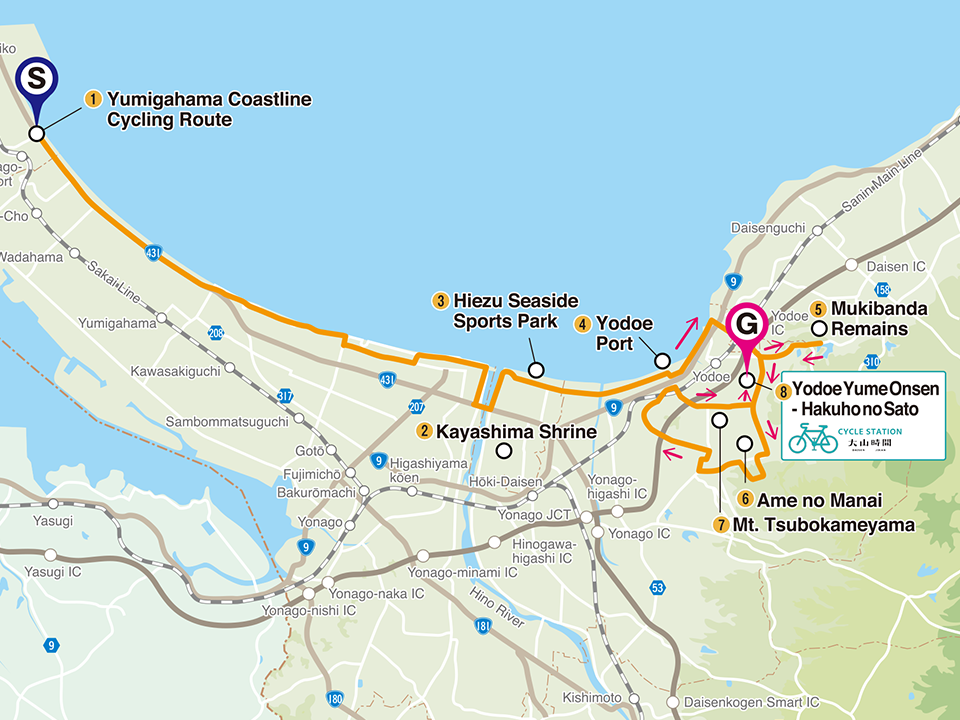

Tourist information for this route

1. Yumigahama Coastline Cycling Route
See Mt. Daisen from across the sea on this picturesque cycling route through sandy beaches and pine forests. The route is mostly flat, making for a comfortable and enjoyable activity whether you are cycling, walking or jogging!

2. Kayashima Shrine
A shrine in the central part of the Minokaya Plain that opens downstream at the Hino River, which flows through western Tottori Prefecture. It is the 'Ubusunagami' (a guardian deity of one's birthplace) of the 29 villages of Kayasho, which covers a larger area than the current Hiezu town. It is named for its location in a slightly elevated area, appearing like an "island" of Kaya.

3. Hiezu Seaside Sports Park
Spend a leisurely and relaxing time at this facility facing a black pine forest. Sports (ground golf, target bird golf) and camping are available.The facility is also equipped with campsites, bungalows, multipurpose spaces and outdoor spaces.

4. Yodoe Port
Tottori Prefecture's most historical fishing port. In the age where Mt. Daisen worship was flourishing, cattle boats frequently arrived from offshore to the cattle market held in the Spring and Fall at Daisen-ji Temple's Bakuroza. Commercial ships large and small came through the Sakaiminato and Shimane peninsula.These days, it is a popular fishing spot for anglers.

5. Mukibanda Remains
Large-scale remains from the Yayoi Period spread out across the Satoyama area of Banda Hill at the base of Sanin's most beloved mountain, Mt. Daisen. More than 400 remains of pit dwellings and over 500 structures have been uncovered on the site. The overlooking view of the Sea of Japan and the beautiful curve of the Yumigahama coastline also makes for a truly spectacular sight.

6. Ame no Manai
A natural beauty famed for its approximately 2,500 tons of crystal clear water that gush out each day, it was named by the Ministry of the Environment as one of the Select Best Waters of Japan. It is a famous water source of the Sanin region and an indispensable resource for local people who use it for daily life, agriculture and rainbow trout farming.

7. Mt. Tsubokameyama
Named so for the many 'tsubo' (pots) and 'kame' (bottles) that were found when it was excavated long ago, it is also known locally as a spot where tea fields spread out far-and-wide and for its views of the Yumigahama Peninsula and Mt. Daisen.

8. Yodoe Yume Onsen - Hakuho no Sato
A free flowing day-trip hot spring in Yonago, Tottori.The weakly alkali and gushing warm hot spring water is rumoured to be excellent for beautiful skin. The onsen is also packed full of amenities, so no need to bring of all your personal items!There is also a cycle station and plenty of car parking spaces available, so it is a great place to stop by on your cycling trip.
How to access the course (starting point)
For cars
About 30 minutes from Yonago Expressway Yonago IC to Yonago Airport.
By train
About 30 minutes from Yonago Expressway Yonago IC to Yonago Airport 10 minutes walk from Yonago Airport Station on the JR Sakaiminato Line.